Game of Mines
This article focuses on the need for Quality Assurance (QA) and Quality Control (QC) in relation to managing geoscientific data within Mining and Exploration. QA and QC are sometimes used interchangeably but, of course, they are very different. QA is a quality framework or policy. It is those practices we put in place to ensure the quality of our data such as the type of certified reference material (CRM) to use and frequency of insertion into a sample despatch.
The emphasis for QC is to test and uncover errors to allow or deny acceptance. An example is a chart displaying analytical results together with control lines for a specific CRM for a laboratory analytical report (Control Chart). QA provides proactive measures. QC provides reactive measures. Together they are referred to as QAQC.
The term QAQC, for some, implies QAQC associated with analytical results. But it should be broader than this. For example, the position of the GPS when taking surface samples is influenced by the number of satellites and their distribution in the sky (Dilution of Position - DOP). A low DOP value indicates the positional precision for the location is not accurate. Conversely a high value indicates reliability for the recorded coordinate.
Consider an idealised horizontal ore-body, say 500m by 500m, 10m thick, depth to top of ore is 90m. We RC to top of ore, core within the ore body and cut 1m samples for analysis:
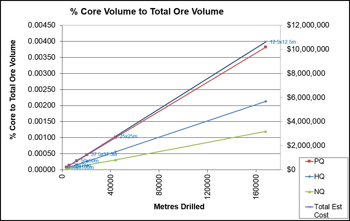
Regardless of the closeness of the drill spacing, the actual volume of core to the overall volume of an ore body is extremely small. Just over 0.002% for 12.5m spacing using HQ in this idealised example. Whilst the volume of data stored in a geoscientific database representing this volume could run into the (tens or hundreds) millions of records, especially if a wireline geophysics program is undertaken, it still represents an extremely small snap shot of the ore body.
Although I have made assumptions about costs, and while this is theoretical, it is interesting to compare the magnitude of amount expended to drill out our very small snapshot. Even at 12.5m spacing. In this example costs are near $6,000,000 for over 160,000m drilled.
If the quality of the underlying data (the support) is suspect, it does not matter how sophisticated our geostatistical or modelling techniques are, any decisions we make are prone to significant risk. In the extreme, it could be the difference between mining when we should not be, or walking away from a project when we should be mining and the problems which may ensue between these extremes.
Data is an asset. It has value, an intrinsic value, which is largely dependent on the costs associated with obtaining and managing this data. It would be an interesting exercise for us all to assign an average (direct and indirect) cost for each sample in the database. This would provide some measure of its intrinsic value.
Data represents knowledge. For example, for mine start-ups, it will be used to prepare a bankable document. It represents our knowledge of the location, orientation, symmetry, geology and concentration of metal (for example) of an body of ore and much more. It is the manifestation of the asset in the ground. We won’t know if our interpretations and modelling are right until we finally mine it out. It is incumbent upon us to manage our data, our asset, to maximise potential and minimise risk. To maintain it’s worth. Remember, whilst we may have a large volume of records, these still represent an extremely small volume of what is in the ground.
QAQC is our friend. A properly designed and enforced ‘across the board’ QAQC program combined with an efficient geoscientific information management system will assist with maintaining quality and minimise risk.
The journey of just one cored (or RC) interval from collection/sampling at the rig through to analysis and resource/reserve modelling is subject to quality risks at every step of the way. As an example, are we confident that that a sample (or geological) interval is correctly located in space?
- Has the orientation of the drill hole been validated? No unusual deviations down hole? If so, these will affect desurveying accuracy below this depth.
- Have different down hole survey methods been used? Which one was used to desurvey and why? Is there some form of ranking to ensure the best ranked survey is used for desurveying?
- Were wireline surveys used? These are often related to magnetic north. Were they corrected to grid north, if this is the case? Was the tool correctly calibrated?
- How was the collar surveyed? If GPS, was DOP considered and, if low, resurveyed again at a different time (better distribution of satellites) or by a different method?
- Has the collar been transformed from another grid? If so, were the down hole survey azimuths adjusted too? If the original grid is at an angle to the destination grid, the orientation of the drill holes is now wrong if not adjusted!
- What desurveying method was used? Tangential, Semi-Tangential, Balanced Tangential, Back Calculation, Split Segments, Spline, Other? Why? Is the method being used consistently? Each method produces differing results:
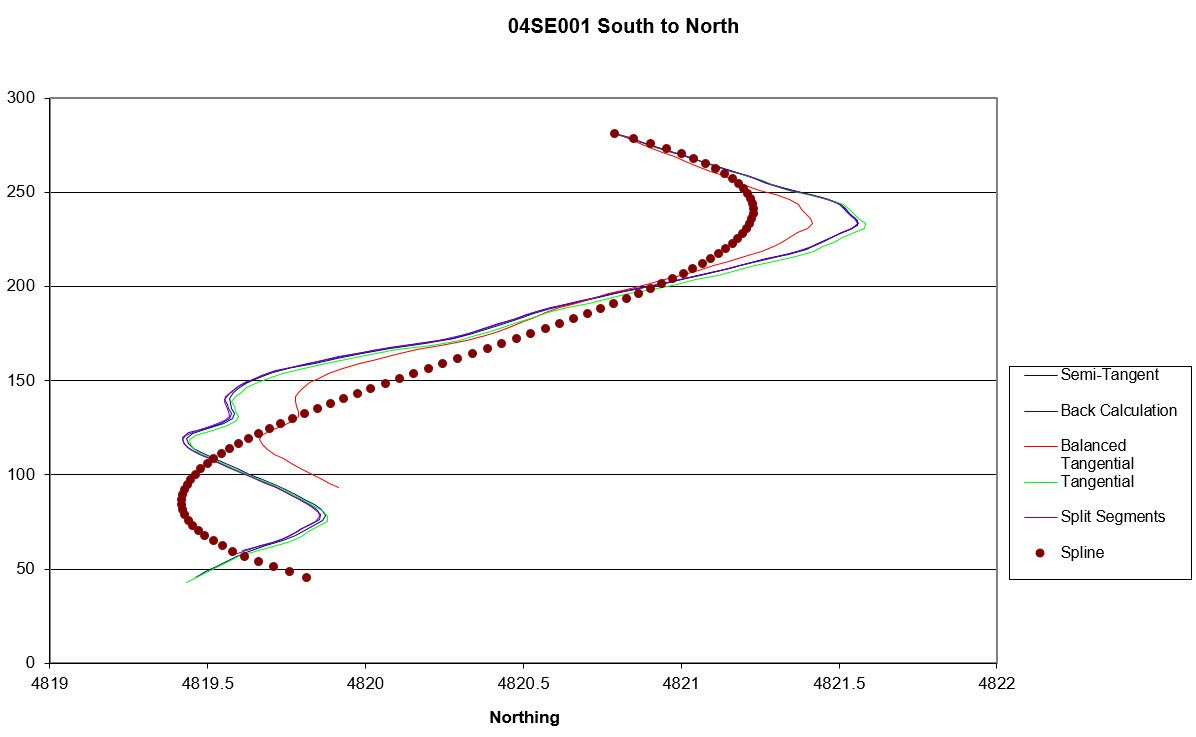
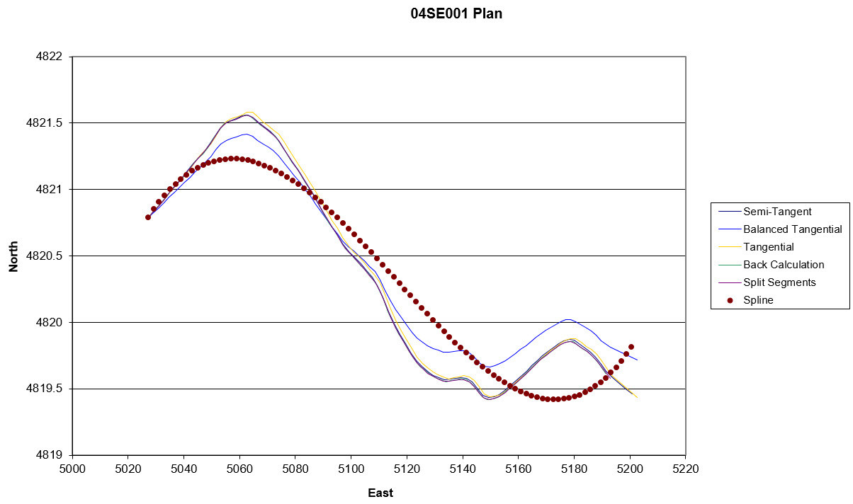
Not huge differences (although Spline should never be considered), but locational variations down hole can be significant from a modelling perspective, especially where there is faulting or knowledge of potential geotechnical issues. As I mentioned earlier, if there are unexplained (and uncorrected) deviations part way down hole, this will wrongly place interval locations below this in space.
What about the risks during logging, sampling and laboratory analysis, interpretations. As an example:
- Have your samplers been appropriately trained. Do they appreciate the importance of unbiased sampling?
- Are your CRM’s fit for purpose?
- Laboratory QC being assessed?
- Sound analytical results QAQC procedures in place and being followed? Is there pressure to get data in and to the modellers/mining engineers. This may well compromise the quality of your valuable data
A risk-ridden hazardous journey for just one sample. Most sites will have ‘across the board’ QAQC measures in place. Even so these should always be reviewed, and maintained. Importantly they must be applied.
I hope this article generates some reflection concerning QAQC at your site. In the past, I have worked in resource modelling for BHP (Yarrie Iron Ore, Cannington Pb-Zn-Ag) and I know only too well how important data quality is.
First published on LinkedIn, 27 October 2017.